Free Online Google Earth Engine Courses and
Certifications 2026
Google Earth Engine is a cloud-based platform that combines satellite imagery, geospatial datasets, and an extensive suite of tools for analysis and visualization. It enables users to explore, analyze, and monitor changes in the Earth’s environment over time. It is used by scientists, researchers, and governments to monitor and analyze global environmental change, manage natural resources, and inform decision-making.
Popular Courses
Learn how to use Google Earth Engine to process geospatial data at scale with this introductory workshop. Presented by Stace Maples, this workshop is designed for complete beginners and will cover the basics of the Earth Engine API, remote sensing, accessing imagery, creating composites, and running analyses. No prior experience with Earth Engine or JavaScript is necessary, but programming experience, basic knowledge of remote sensing and/or GIS are highly desirable. Sign up now to get started!
Learn More
This course, Developing Real Time Applications with WebRTC, provides an overview of the WebRTC technology and how it can be used to create real-time applications. It covers topics such as how WebRTC works, how to share media with other people, and how to design and debug a WebRTC application. The course also provides access to additional video tutorials and resources.
Learn More
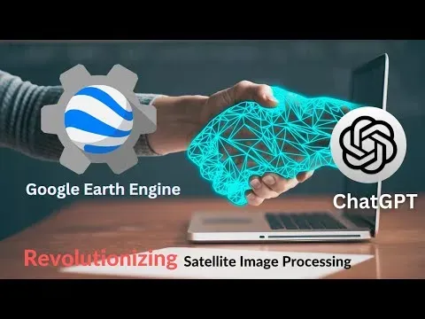
ChatGPT and Google Earth Engine are a match made in heaven for satellite image processing. With ChatGPT's powerful AI and Google Earth Engine's vast library of satellite imagery, you can quickly and easily process satellite images with unprecedented accuracy and speed. Learn how to use these two tools together to get the most out of your satellite image processing projects.
Learn More
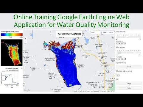
This 3-day online training program on Google Earth Engine for Air & Water Quality Monitoring using Remote sensing techniques is the perfect opportunity to learn the necessary skills to start using GEE for your remote sensing analysis. With a fee of 500 dollars, the first 5 registered people get a 50% discount of only 250 dollars. Learn how to map O3, NO2, SO2, HCHO, CHOCHO and aerosols, CO, CH4, and stratospheric O3 density, make time-series charts, download air quality parameters time series data in CSV format, convert units, export maps, and more. Also, learn about NDTI, NDCI, NDWI, AWEI, TSS remote sensing model, turbidity remote sensing model, chlorophyll, and time series chart for TSS, turbidity, and chlorophyll. Take advantage of this discount and register now!
Learn More
This course explores the potential salary range of venture capital investors. It examines the motivations behind becoming a venture capitalist, and provides insight into the investor mindset. Through street interviews in Los Angeles, the course provides an in-depth look at salary transparency and the potential earnings of venture capitalists.
Learn More
This course provides a comprehensive introduction to remote sensing and GIS analysis using Google Earth Engine (GEE). Learn to process petabytes of satellite imagery data and carry out practical, real-life remote sensing and GIS analysis tasks in this powerful cloud-supported platform. Taught by an Oxford and Cambridge graduate with years of experience in analyzing remote sensing data, this course will help you become an expert in geospatial analysis. Get the skills you need to stand out in the job market and save thousands of dollars on expensive software. Enroll now and take an important step forward in your GIS journey.
Learn More
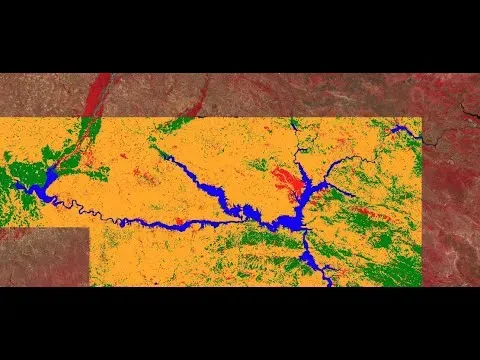
This course is designed to take users who use GIS for basic geospatial data/GIS/Remote Sensing analysis to the next level. Learn how to use Google Earth Engine for land use and land cover (LULC) mapping and change detection. With this course, you will gain the practical knowledge of unsupervised and supervised classification strategies for LULC mapping, and be able to apply advanced Geospatial analysis and Machine Learning algorithms. You will also learn how to acquire satellite data, assess the accuracy of your map, and design a beautiful change map. This course is ideal for professionals such as geographers, programmers, social scientists, geologists, and all other experts who need to use LULC maps in their field. With the practical exercises, you will gain the confidence to understand and solve geospatial problems. Don't miss out on this opportunity to improve your GIS and Remote Sensing skills and knowledge of the cutting edge LULC techniques.
Learn More
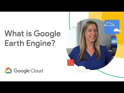
Discover the power of Google Earth Engine and how it can help you accelerate impact within your organization. With over a decade of experience, Earth Engine provides a geospatial analytics platform that couples planet-scale data with the computing power of Google's infrastructure. Learn more about Earth Engine and see what you can accomplish by watching this video. It covers topics such as the Earth Engine data catalog, development flexibility, and business drivers for using Earth Engine. Take the next step and subscribe to Google Cloud Tech to get started.
Learn More
This Google Earth Engine Mega Course: Remote Sensing & GIS is the only course you need to learn to code and become an Earth Engine expert. With a 4.8 average rating, it is one of the highest-rated courses. Over 12 hours of HD video tutorials, this comprehensive course will take you from beginner to mastery, even if you have zero programming experience. Taught by an experienced spatial data scientist and former NASA fellow, the course is updated to be 2023-ready and covers topics such as Landsat Image Visualization, Image Collection Metadata, Mapping Feature Collections, Raster to Vector Conversion, and more. Join the highest-rated Google Earth Engine course and become an Earth Engine expert today!
Learn More
Learn how to properly prepare your remote sensing time-series for regression and trend analysis with Geo for Good 2022. Ujaval Gandhi from Spatial Thoughts will cover techniques for processing remote sensing time-series data for analysis along with their implementation in Google Earth Engine. Discover how to replace cloudy pixels and interpolate missing time-steps, as well as moving-window smoothing and savitzky–golay filtering. Join the session and view the video and slides on the Geo for Good Summit website.
Learn More
Learn how to install the Earth Engine Python API and load Landsat satellite data using a Jupyter Notebook with this tutorial for absolute beginners. Get started with the Earth Engine Python API and explore the geemap library. Subscribe to SpatialeLearning for more tutorials and watch the YouTube playlists for Google Earth Engine JavaScript API, Python for Spatial Data Analysis, and more. Follow the course on social media for updates.
Learn More
This course, How to Play Shakuhachi, taught by JonKypros.com's Dai-Shihan 'Grandmaster', provides an extensive introduction to the traditional Japanese bamboo flute. Through free lessons, learners can gain an understanding of the instrument and its history, as well as the basics of playing the shakuhachi.
Learn More
Frequently Asked Questions and Answers
Q1: Is Earth Engine free?
Earth Engine is now available for commercial use, while continuing to remain free for academic and research purposes. The impact of Earth Engine on the Earth can be observed from a fresh perspective by exploring 37 years of satellite imagery in Timelapse within Google Earth. Timelapse serves as an illustration of how Earth Engine facilitates the extraction of valuable insights from massive datasets, measured in petabytes.
Q2: How do I use Google Earth?
Placemarks can be added to highlight key locations in a project, and lines and shapes can be drawn directly on the map. The map can feature images and videos to provide rich contextual information. The detailed globe of Google Earth can be utilized by tilting the map to obtain a perfect 3D view or by diving into Street View for a 360-degree experience.
Q3: What Google Earth Engine courses can I find on OeClass?
On this page, we have collected free or certified 34 Google Earth Engine online courses from various platforms. The list currently only displays up to 50 items. If you have other needs, please contact us.
Q4: Can I learn Google Earth Engine for free?
Yes, If you don’t know Google Earth Engine, we recommend that you try free online courses, some of which offer certification (please refer to the latest list on the webpage as the standard). Wish you a good online learning experience!

![FULL COURSE - Google Earth Engine Python API and Colab for Absolute Beginners in 3 Hours [2023]](https://img.heomai.com/allimg/site_courses/2025-01/911564f124cdd4dc138ffbea8f3d287.webp)