Complete Google Earth Engine for Remote Sensing & GIS

This course provides a comprehensive introduction to remote sensing and GIS analysis using Google Earth Engine (GEE). Learn to process petabytes of satellite imagery data and carry out practical, real-life remote sensing and GIS analysis tasks in this powerful cloud-supported platform. Taught by an Oxford and Cambridge graduate with years of experience in analyzing remote sensing data, this course will help you become an expert in geospatial analysis. Get the skills you need to stand out in the job market and save thousands of dollars on expensive software. Enroll now and take an important step forward in your GIS journey.▼
Course Feature
![]() Cost:
Cost:
Paid
![]() Provider:
Provider:
Udemy
![]() Certificate:
Certificate:
Paid Certification
![]() Language:
Language:
English
![]() Start Date:
Start Date:
2022-10-02
Course Overview
❗The content presented here is sourced directly from Udemy platform. For comprehensive course details, including enrollment information, simply click on the 'Go to class' link on our website.
Updated in [July 25th, 2023]
This course provides a comprehensive introduction to basic satellite remote sensing and GIS analysis using Google Earth Engine (GEE). Participants will gain a foundation in practical, real-life remote sensing and GIS analysis tasks in this powerful cloud-supported platform. The instructor, an Oxford University MPhil (Geography and Environment) and Cambridge University PhD (Tropical Ecology and Conservation) graduate, has several years of experience in analyzing real life spatial remote sensing data from different sources and producing publications for international peer reviewed journals.
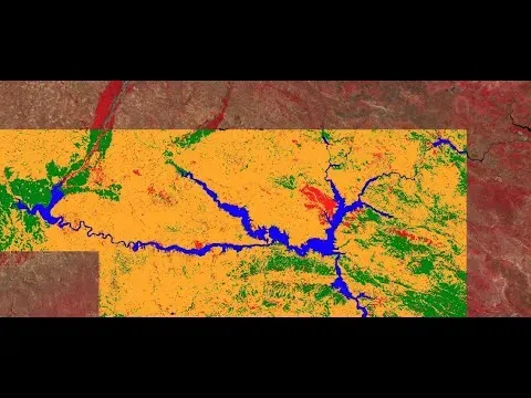
The course will use actual satellite remote sensing data such as Landsat from USGS and radar data from JAXA to give a practical hands-on experience of working with remote sensing and understanding what kind of questions remote sensing can help answer. Participants will learn the most important and widely encountered remote sensing data processing and GIS analysis techniques in Google Earth Engine, as well as the different sources of remote sensing data and how to obtain them free of charge and process them within GEE.
The instructor will provide continuous support to ensure participants get the most value out of their investment. Enrollment is open to those currently enrolled in any of the instructor's GIS and remote sensing related courses, those with prior experience in GIS or tools like R and QGIS, and those who do not want to spend hundreds or thousands of dollars on buying commercial software for imagery analysis.
Course Provider