The Ultimate Guide for Land Surveying with Drones - Part 2

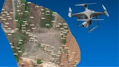
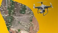
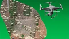
This course is the second part of the 3 course series “The Ultimate Guide for Land Surveying with Drones”. It covers the steps involved after processing drone survey images, including post processing with software applications such as QGIS, AutoCAD, Google Earth Pro and Gimp. It also teaches how to create the best reports for clients and how to turn the knowledge into a profitable business. With over 4000 enrollments across 114 countries since its release 10 months ago, this course is a must for anyone who wants to do more than just process drone images. Reviews praise the course for its visuals, technical detail and use of open source software. Don't miss out on this opportunity to learn the skills to make your drone survey business successful.▼
Course Feature
![]() Cost:
Cost:
Paid
![]() Provider:
Provider:
Udemy
![]() Certificate:
Certificate:
Paid Certification
![]() Language:
Language:
English
![]() Start Date:
Start Date:
2021-11-09
Course Overview
❗The content presented here is sourced directly from Udemy platform. For comprehensive course details, including enrollment information, simply click on the 'Go to class' link on our website.
Updated in [July 27th, 2023]
This course is the second part of the 3 course series “The Ultimate Guide for Land Surveying with Drones”. It covers the steps involved after the processing of images from a drone survey. Post processing is detailed using various software applications such as QGIS, AutoCAD, Google Earth Pro and Gimp. Additionally, the course provides instruction on how to create the best reports for clients and how to convert the knowledge gained into a sustainable and profitable business. This course is a continuation of the first course and is also useful for those already in the drone survey business. Since its release 10 months ago, the course series has had over 4000 enrollments across 114 countries. Reviews of the course have been overwhelmingly positive, with many noting the clear visuals and step-by-step instructions, as well as the use of QGIS open source software.
Course Provider